-
by pltm

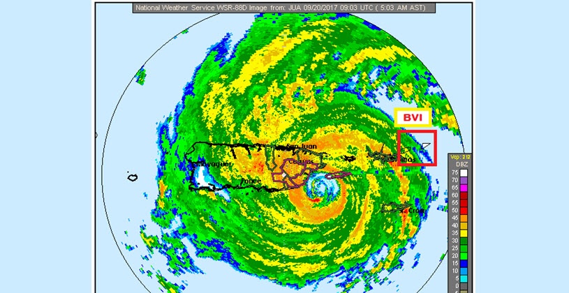
(PLTM) - At 500 AM, the center of Hurricane Maria was located near latitude 17.9 North, longitude 65.6 West. Maria is moving toward the northwest near 10 mph. A west-northwest to northwest motion is expected to continue through today, followed by a northwestward motion on Thursday.
On the forecast track the eye of Maria will make landfall in Puerto Rico in a couple of hours, cross Puerto Rico today, and pass just north of the northeast coast of the Dominican Republic tonight and Thursday.
Maximum sustained winds are near 155 mph with higher gusts. Maria is an extremely dangerous category 4 hurricane on the Saffir-Simpson Hurricane Wind Scale, and it should maintain this intensity until landfall.
Hurricane-force winds extend outward up to 60 miles from the centre and tropical-storm-force winds extend outward up to 150 miles. Fajardo recently reported sustained winds of 79 mph with a gust to 100 mph.
The minimum central pressure recently reported by an Air Force Hurricane Hunter aircraft is 917 mb.
Satellite data and aircraft data indicate that Maria has weakened over the past several hours due to an eyewall replacement cycle. Winds have decreased to 155 mph. While Maria should weaken a little before it reaches San Juan, Forecasters think project winds to be no less than 150 mph when the eye reaches San Juan. The eye should be around San Juan in a few hours.
After moving through Puerto Rico, confidence is fairly high that Maria will pass north of the Dominican Republic and move near the Turks and Caicos Islands. Longer term, the model guidance continues to shift the track slightly closer to the United States East Coast.
IMPACTS
RAINFALL: Maria is expected to produce total rain accumulations of 8 to 12 inches with isolated maximum amounts of 16 inches.
WIND: Gusty winds can cause debris to become airborne. Persons should stay indoors until an indication of safety is given to venture outside.
STORM SURGE: A dangerous storm surge accompanied by large and destructive waves will raise water levels by as much as 6 to 9 feet above normal tide levels.
-----
Copyright 2023 by Virgin Islands Platinum News. All rights reserved. This material may not be published, broadcast, rewritten, or redistributed.