-
by pltm

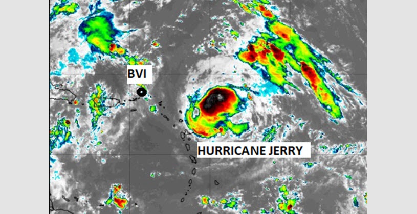
(PLTM) - At 800 AM AST (1200 UTC), the centre of Hurricane Jerry was located near latitude 18.5 North, longitude 59.6 West. Jerry is moving toward the west-northwest near 16 mph (26 km/h). A west-northwest to northwest motion at a decreasing forward speed is expected over the next few days.
On the forecast track, the center of Jerry will move North of the British Virgin Islands on Saturday.
Maximum sustained winds have decreased to near 100 mph (155 km/h) with higher gusts. A gradual weakening trend is forecast to continue today, but Jerry is expected to remain a hurricane during the next few days.
Hurricane-force winds extend outward up to 25 miles from the centre and tropical-storm-force winds extend outward up to 80 miles.
An Air Force Reserve Hurricane Hunter aircraft has recently reported a minimum central pressure of 989 mb.
Hurricane-force winds extend outward up to 25 miles from the centre and tropical-storm-force winds extend outward up to 80 miles.
The estimated minimum central pressure is 989 mb.
Impact on the British Virgin Islands
Possible gusty winds from outer rain bands Rainfall estimates of 4 – 6 inches is possible on Anegada Rainfall estimates of 1 – 3 inches is possible on the remaining Islands of the BVI Rough sea conditions especially on the north side of the Islands High Surf Warning is in effect (see separate post on Facebook for details).
What to do
Keep monitoring the system as it progresses further westward for any change in its path and intensity.
Check drainage paths or specific areas to ensure debris is not blocking those locations.
Stay away from swimming activities at this point.